
Enterprise Solution
Climate Engine is a partnership with Google to accelerate and scale the use of Earth observation data to deliver mission critical data insights.
Leverage the power of Google Cloud + Geospatial.
Reach out to learn more.
Climate Engine helps Google Cloud accelerate and scale the implementation of Earth Engine to deliver an Enterprise Solution. We do this to help organizations deliver on commitments to sustainability and climate resilience.
Earth observation data and analytics have transformative potential.
The planet is changing at unprecedented rates. Current and future economic and environmental security depends on our ability to keep up with, understand, and respond quickly to these changes. Earth observations insights are the best tools we have to do this.
For organizations to take advantage of this promise, challenges need to be overcome. These include managing the scope and scale of the data, converting raw data into actionable insights, and bringing the best available science into operational contexts.
An Enterprise Architecture on Google Cloud Platform
In partnership with Google, Climate Engine is an Enterprise level deployment of Google Earth Engine. It provides organizations with a centralized system to ingest, process, and deliver Earth data into decision making contexts.
Google Earth Engine is the world’s most powerful Earth observation data processing system. With 400+ high value data sets including Landsat, Sentinel, and other sources natively ingested into its system, it can process global insights at hyper-local levels at unparalleled speeds and scales. Climate Engine provides a number of accelerators to combine the power of Google Earth Engine with Google Cloud to provide a deployable enterprise solution within an organization’s own GCP infrastructure.
The following graphic depicts the architecture and how it functions to transform data into insights delivered to decision making context via API:
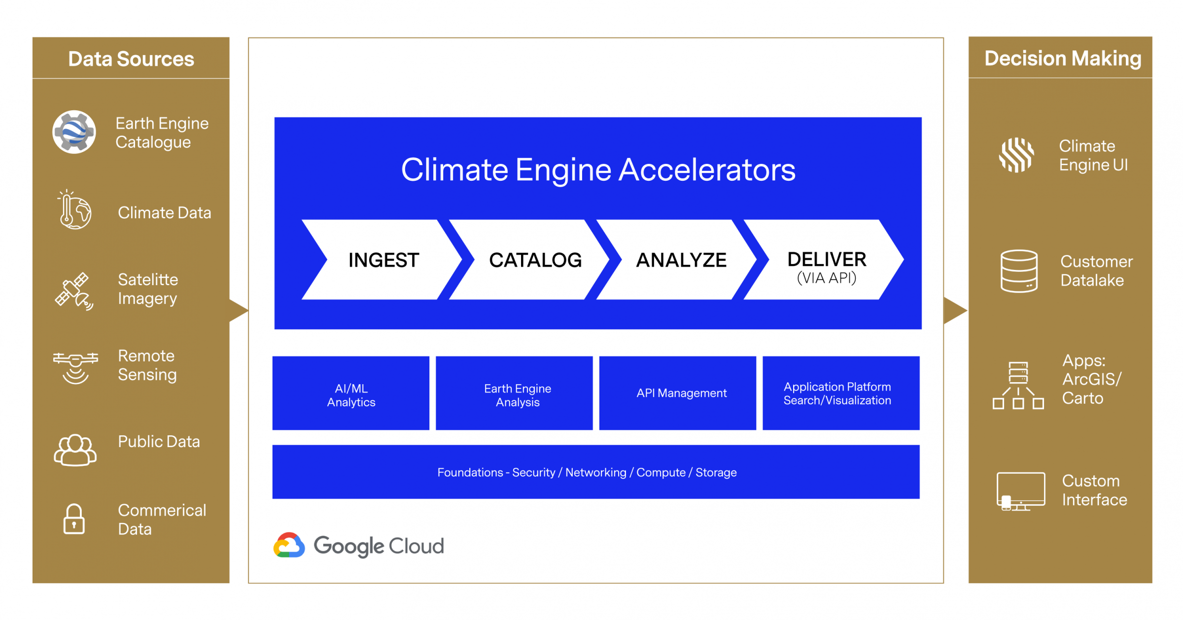
Climate Engine Accelerators: Scaling Google Earth Engine for Enterprises
At the core of Climate Engine is a series of accelerators that help organizations better deliver Earth observation data at enterprise scales by leveraging the power of Google Earth Engine and Google Cloud. These accelerators include:
01
INGEST
This accelerator ingests raw data from multiple sources and converts them into operable formats. These data sources include the 400+ Google Earth Engine data collection (including Landsat, Sentinel, MODIS, weather, climate, and more) that are native on Google Cloud, commercial data sources such as Planet, public/government data sources, non space-borne imagery such as LIDAR and drone data, and private data sources that belong to enterprises.
Features include:
- -UNIFIED API REGARDLESS OF DATASOURCE
- -STAC-COMPLIANT DATA ACCESS LAYER
- -ORDERS API FOR ACCESS TO & INGESTION OF PROPRIETARY DATA
- -AUTOMATIC COG CONVERSION
- -AUTOMATIC CRS RE-PROJECTION (WGS84)
- -OGC COMPLIANT
- -DATA NORMALIZATION
- -ON-THE-FLY FILE FORMAT CONVERSION (TIFF, PNG, JPEG, NUMPY)
02
CATALOG
Once the data has been ingested, it is then placed into a catalog for indexing and discovery. This step super-charges the analysis capability as it creates an easy to use repository of all relevant raw data sources.
Features include:
- -AUTOMATIC METADATA EXTRACTION AND INDEXING
- -AOI/TOI SEARCH & DISCOVERY WITH PAGED RESULTS
- -AUTOMATIC IMAGE SEGMENTATION AND AOI DOWNLOAD
- -AUTOMATIC INFRASTRUCTURE SCALING
- -EARTH ENGINE DATA LIBRARY NATIVELY AVAILABLE INCLUDING: LANDSAT, SENTINEL, MODIS, WEATHER, CLIMATE (400+ DATASETS)
03
ANALYZE
Once the data is in the catalog, scientific models can be processed to analyze the data. This accelerator runs the data that is in the catalog through Google Earth Engine to extract actionable insights.
Features include:
- -CALLS TO CLIENT GOOGLE EARTH ENGINE
- -NATIVE STATISTICAL ANALYSIS: MAX, MIN, MEAN, MEDIAN, STANDARD DEVIATION, PERCENTILES, COUNTS, TRENDS, CLIMOS
- -TILE SERVER FOR LIVE VIEWING AND EXPLORATION
- -AI/ML ANALYSIS READY
- -ACCESS TO LIBRARY OF 70+ PRE-CODED, HIGH-VALUE EARTH ANALYSIS APIS TO REDUCE MODEL COMPLEXITY
04
DELIVER (via API)
Once the data is processed using scientific models, the outputs are coded so they can be accessible via an API (Application Programming Interface). This allows the outputs to be brought into decision making contexts or platforms including ESRI, QGIS, Carto, data lakes, and/or custom user interfaces.
Features include:
- -NO CODE GEOSPATIAL & CLIMATE ANALYSIS
- -QGIS, ESRI, ARCGIS INTEGRATION
- -FULLY AUTOMATED, SINGLE COMMAND DEPLOYMENT TO GOOGLE CLOUD PROJECT
- -ALL SERVICES SEND LOGS TO CLOUD LOGGING FOR MONITORING AND DEBUGGING
- -ALL SERVICES ARE PROTECTED BY APPROPRIATE IAM POLICIES
- -USER AUTHENTICATION, PERMISSIONS, AND MANAGEMENT VIA USER API MICROSERVICE
Why an Enterprise Solution for Google Earth Engine?
Large scale enterprises and governments at risk.
We are in the midst of global change that is unprecedented in human history and these changes are accelerating. While these changes are happening globally, the impacts of these changes are felt locally through extreme weather events such as flood, drought, and wildfire that are increasing in scale and frequency.
To meet these risks, large scale enterprises and governments must keep up with, understand, and respond quickly to these changes. Their ability to respond to existential climate threats is entirely dependent on delivering large scale geospatial insights for decision making. As such, an enterprise level Earth observation system is a core piece of infrastructure for organizations looking to minimize their risks and better understand opportunities.
Meeting the need for enterprise level Earth observation data is at the core of Climate Engine and its partnership with Google Cloud. Together, we help organizations take advantage of the full wealth of available data to help deliver the best available science into decision making contexts.